Location
Cedar Lake Parkway
Minneapolis, MN 55416
Plan Your Route
Contact
Phone: 612-230-6400
Email: info@minneapolisparks.org
Park Hours
6 am-midnight in developed areas
6 am-10 pm in undeveloped areas
Ordinance PB-2-33
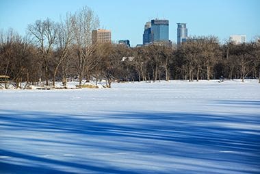
Cedar Lake Park
Part of: Minneapolis Chain of Lakes Regional Park
Nearby Recreation Center: Kenwood Community Center
Features & Amenities
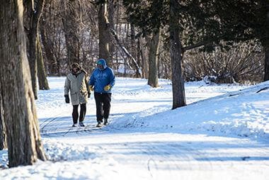
- Biking Path
- Cross-Country Ski Trail
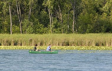
- Fishing Pier
- Grill
- Pay Parking Lot
- Picnic Area
- Walking Path
- Well
Not finding what you’re looking for?
Search Parks & Destinations
Good to Know
Beaches:
Connected to:
Fishing Pier located at the intersection of West 22nd Street and Cedar Lake Parkway.
Nearby Trails:
- Cedar Lake Parkway
- Cedar Lake Regional Trail
- Kenilworth Trail
Picnic Areas are non-reservable.
Wells are located at:
- West 21st Street & South Upton Avenue
- North Cedar Lake Regional Trail
- Cedar Lake South Beach
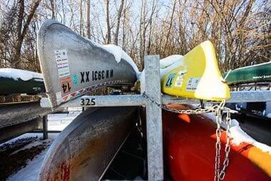
Canoe launch and rack located on west side of lake.
A pay parking lot is available.
Park Projects
See what’s currently in the works for this park. Some projects may be under the name of the regional park or service area it lives within. View Current Projects

Park Details
Size: 288.1 acres
Trail: Pedestrian (1.68 miles), Bike (1.68 miles)
Neighborhood: Bryn-Mawr, Kenwood, Cedar-Isles-Dean, and Outside Minneapolis City Limits
Service Area: 4
Commissioner District: Southwest
The lake offers ample shore fishing opportunities; the West side fishing pier is a great spot for catching northern pike, muskie and bass.
Lake Info
Cedar Lake is monitored as part of the Minneapolis Park & Recreation Board’s (MPRB) lake water quality monitoring program.
Click here for MPRB lake monitoring info
The Minnesota Department of Natural Resources has details regarding the size, shore length, depth, and other features of the lake.
Rentals & Permits
Canoe/Kayak Storage Rack Permit: An annual permit allows you to store your canoe or kayak. View canoe/kayak permit details.
Outdoor Use and Event Space: Learn how to reserve park space for corporate events, community celebrations, and more.
Parkway Use: You must obtain a permit for special use of the parkway including closures, and dumpsters, trucks, limousines or carriages on the parkway. View parkway permit details.
Beach Group Use Permit: Apply for a free permit to ensure we can accommodate your birthday party or group of 10 or more at the beach. Visit Beach Group Use Permit for details.
Annual Patron Parking Permit: Enjoy parking privileges in specially designated spaces at some of our most popular regional parks. View parking permit details.
History
Name: The lake was named long before the park board was created for the red cedar trees that once grew on its shores.
Acquisition and Development
No lake in the Minneapolis park system was considered for acquisition as a park for so long and took so long to acquire as Cedar Lake. Even before Lake of the Isles was acquired in 1886, the park board was considering proposals to acquire the western shores of Cedar Lake as a parkway that would loop from Central (Loring) Park to Prospect (Farview) Park in north Minneapolis. The appeal of the route, similar to the appeal of parkways around Lake Harriet and Lake of the Isles, was that landowners had offered to donate much of the land for that parkway.
The park board discussed the route with William McNair, the owner of much of the land along the route (and the law partner of early park commissioner and park board attorney Eugene Wilson), however some park commissioners thought the route was too far from the city to be of much use. Regardless of divided opinion on the acquisition, the issue was dropped when McNair died in 1885. Landscape architect Horace Cleveland did not mention Cedar Lake in the blueprint he was asked to prepare for the new park system in 1883. Cleveland’s focus was much more on acquiring the banks of the Mississippi River than on acquiring the shores of the distant lakes. It was Cleveland’s idea of a system of parkways connecting features of natural interest, however, which kept alive the idea of a parkway around Cedar Lake.
When Cleveland’s friend and former University of Minnesota president William Folwell urged the park board to plan carefully the expansion of the park system in 1891, he suggested a parkway around Cedar Lake to connect to Glenwood (Wirth) Park and then continue north to a large, yet-to-be-acquired park in the northwest part of the city.
Cedar Lake came up at park board meetings several times in the 1890s, including an offer from McNair’s heirs to donate land for a parkway in 1894 to connect Dean Parkway with Glenwood Park, but no action was taken. As president of the park board William Folwell again recommended adding Cedar Lake to the park system in 1899. His advice was seconded by landscape architect Warren Manning who was hired to advise the board in 1899 after Cleveland had retired.
With the clamor for more parks nearly everywhere in the city, however, the park board didn’t seriously consider acquiring Cedar Lake again until 1905. In that year’s annual report park board president Fred Smith made note of petitions to acquire the west shore of Cedar Lake in the context of plans to enlarge Glenwood Park. Once again Cedar Lake was viewed principally as a scenic connection from north Minneapolis to the parkways around Lake of the Isles and Lake Harriet. (The west shore of Lake Calhoun wasn’t yet a park either.) Another petition from citizens in 1905 asked for the linking of the lakes, including Cedar Lake, by a navigable channel.
Finally, at the same time it was designating land to enlarge Glenwood Park, the park board designated just enough land along the west shore of Cedar Lake to “secure shore rights” and build a parkway. The land acquired stretched 1¾ miles from the railroad bridge on the northwest shore of the lake to a point near Dean Parkway between Lake Calhoun and Lake of the Isles. The cost of most of the land was $1,200.
Later that summer the park board also accepted a donation from Anna Lewis of land between Cedar Lake and Lake of the Isles to create a channel between the lakes. (Lewis was later paid $1,000 for that land when the park board couldn’t complete the channel in time to comply with the conditions of her donation. The channel was scheduled for completion about the same time as a channel from Lake of the Isles to Lake Calhoun, but faulty engineering on the new bridge over the yet-to-be dug channel on the west side of Lake of the Isles caused that bridge to be rebuilt, thus delaying the connection.)
Park superintendent Theodore Wirth included a plan for Cedar Lake improvements in the 1909 annual report, primarily to show the proposed connection with Lake of the Isles. The map is also interesting because it shows the shore line of Cedar Lake before the water level dropped five feet after the connection with Lake of the Isles was made. A dotted line on the map shows where the water level was expected to be after the connection, creating considerable additional land for the parkway and making a peninsula of an island near the lake’s western shore. The channel between the lakes was finally opened in 1913—after the dredges had completed their first round of dredging on Lake Calhoun—and the level of Cedar Lake dropped as expected.
Before the dredging on Cedar Lake began, the Women’s Christian Association donated two-plus acres of meadow and wetland southwest of Cedar Lake for a park in 1912. That year Wirth also recommended that the park board acquire all the shores of Cedar Lake.
Despite inaction on that recommendation, the park board proceeded with the linking of Cedar Lake to Lake of the Isles in 1913 and began construction of the parkway south and west of the lake on the additional land that was created by lowering the water level. It was only as Cedar Lake was linked to Lake of the Isles that park commissioner Wilbur Decker first recommended also linking Cedar Lake with Brownie Lake. Wirth expressed his support for that action in the 1915 annual report and suggested that the board pay the extra cost of constructing a more appealing concrete bridge for the railroad over that proposed channel, instead of the more utilitarian steel-girder bridge the railroad was willing to construct.
Dredges hired by the park board were busy at Cedar Lake from 1913 to 1916 deepening the lake, generating fill for the parkway and connecting to Brownie Lake, which was completed in 1917. Wirth noted in the annual report for 1917 that dredging in Cedar lake had been much more difficult than expected due to the coarse gravel found on the lake bottom. With the improvements to the lake, board president Francis Gross called once again for the acquisition of the entire lake. “This beautiful lake,” he wrote, “its shores only partially parked, is now like a picture incompletely framed.”
Late in 1917 the board instructed Wirth to present a plan for acquiring the remainder of the lake and he presented that plan in the summer of 1918. The board voted to place the report on file, noting that the land should be acquired “at the proper time.” In 1921 Wirth presented a plan for the development of Cedar Lake that included athletic fields on the east shore and in the southwest meadow, and tennis courts in three locations west of the lake, including four on the new peninsula created when the lake was lowered. Despite repeated recommendations from Wirth over the next several years to proceed with that acquisition, the “proper time” didn’t arrive for almost forty years.
With the many other major acquisitions and improvement projects under way in the early 1920s, it is not surprising that the board did not acquire the remaining shores of Cedar Lake, even though Wirth suggested in 1920 that the value of the land, particularly on the north side of the lake, “should not be very high.” What is more surprising is that the new Cedar Lake Boulevard along the western and southern shores did not connect to Dean Parkway. A gap of 750 feet existed in the park board’s ownership of land between the two parkways. A city street did connect the two parkways, but the park board didn’t control that one short stretch where it crossed the railroad tracks. In proposing a bridge over the railroad tracks to connect the parkways in 1921, Wirth called it “one of the worst railroad grade crossings in the city, and the most dangerous point of the Grand Rounds.”
At the same time, Wirth admitted that the improvements to Cedar Lake were not as high a priority as improving Kenwood Park because the same property would be assessed for both projects. Kenwood Park had been owned by the park board for 14 years with almost no improvements and Wirth’s plans for Kenwood Park had been gathering dust that whole time.
Cedar Lake Boulevard was improved in 1923, but there was still no grade crossing to Dean Parkway. It wasn’t until 1929 that the grade crossing was finally improved to make it less dangerous, but no bridge was built. The city and the railroad paid for the grade crossing improvements, but the work was done by park board crews. At that time, perhaps weary of his nearly annual recommendation that the north and east shores of the lake be added to the park system, Wirth recommended that the acquisition of that land should take place when the “Southwest Diagonal” was undertaken. The Southwest Diagonal was a proposed thoroughfare from what is now I-394 to the southwest that would have passed beside the railroad tracks near Cedar Lake. It was never built. With the coming of the Great Depression, followed by World War II, very little was done to maintain the park system, let alone expand it—or build new roads through the city.
In 1933 a land developer offered to donate a strip of land on the east shore of the lake for a parkway and the park board accepted the offer of a little more than an acre of land, which gave the park board its first small piece of the eastern shore of the lake. The donation was valued by the park board at $5,000.
Cedar Lake did not feature prominently in park board plans or proceedings during the 1930s and 1940s. Part of the southwest meadow was designated during the depression as a vegetable patch for the Minneapolis Direct Relief Committee. Another interesting mention of the lake was in 1934 when the Cedar Lake Ice Company sponsored the community sings in parks throughout the city. Because Cedar Lake was not wholly owned by the park board, ice was still harvested from the lake to be used throughout the year in “ice boxes.” Ice harvesting had been terminated on other lakes, especially Lake Calhoun, when the park board had acquired them.
The park board’s “Postwar Progress” list of $11.7 million in proposed acquisitions and developments in 1945 did not include the acquisition of Cedar Lake. The list was generated as part of a city-wide effort to identify projects that could help stimulate the economy after the war and redress years of “deferred maintenance.” The park board’s focus was on acquiring and developing neighborhood recreation parks in parts of the city that had been neglected for decades, not on adding lake shore and parkways to its inventory. Few projects on the park board’s list were funded by city bonds until the 1960s, even though the City Planning Commission recommended in 1950 that the east and north shores of Cedar Lake be acquired as a park.
That recommendation was followed in 1953 by the park board seeking and obtaining from the Minnesota legislature legal control of the waters of Cedar Lake, even though it didn’t own the entire shoreline.
In 1954 and 1955 the park board took additional steps to acquire all of the lake by adding nearly nine acres of land to its holdings on the east shore at a total cost of about $32,000. With the final five acres acquired in 1955, paid for with proceeds from the sale of land west of Brownie Lake to The Prudential Insurance Company in 1952, the board reported that it had completed the acquisition of the east shore. The land was purchased without comment in the park board’s annual reports of 1954 and 1955 suggesting that the acquisitions had not been among the park board’s highest priorities. In 1956 the park board initiated proceedings to acquire additional land on the east shore by condemnation, which resulted in nearly 19 acres being purchased in 1958 at a cost of about $13,000.
The park board added the last piece of Cedar Lake’s shore in 1959 when it designated the north shore of the lake for acquisition from the railroad. The final piece of shoreline cost the park board approximately $15,000. For that sum, the park board added to its inventory of parks not only the nine acres of land purchased, but the 173 acres of the lake’s surface.
With that act, the park board completed its acquisition of the all the major bodies of water in the city—river, lakes and streams—with the exception of the Mississippi River banks at and above St. Anthony falls. Seventy-six years after the park board was created in part to preserve for public use the shores of the city’s lakes and the banks of its river it had succeeded in acquiring nearly all of the city’s land that bordered water.
Fourteen acres were added to the park in 1968.
Cedar Lake Parkway was paved in 1977 and new lighting and paths were installed at the same time.
The most significant change on the land owned by the park board near the lake occurred when the park board initiated a project in 1995 to improve the water quality of the lake. A new storm water pond and wetland was created southwest of the lake in 1995-1996 to filter storm water runoff. Cedar Lake also received an alum treatment in 1996 in a further attempt to improve water quality.
Extensive improvements to the east beach, known as Hidden Beach, were competed in 2007. A lifeguard stand, portable toilet and picnic tables were added and considerable landscaping, including removal of invasive species, was completed to open up the area around the beach.
Significant improvements were made to the trails near Cedar Lake in 2013.
The park board engaged in complex negotiations over a plan to run passenger trains from the proposed Southwest Light Rail Transit line through the Kenilworth Channel between Cedar Lake and Lake of the Isles. In 2010 it formed a Community Advisory Committee to advise the park board regarding the project’s impact on park land. In 2012 the park board first formally stated its opposition to the proposed route traveling over Kenilworth Channel.
In 2014 engineers were hired to take a closer look at alternatives to the proposed bridge needed to cross the channel. After careful examination of the report issued by the engineers and consulting with its legal team, the park board determined an alternative option – tunneling under the channel – was feasible but it added construction time and cost to the project that rendered it not prudent.
In February 2015 the park board reached an understanding with the Metropolitan Council, the public agency overseeing the project, and later that year the park board approved the design of new bridges over the channel.
History through 2008 written by David C. Smith, with updates from 2009 to present written by MPRB.